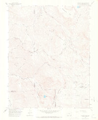
1966 Map of Elwood Pass
USGS Topo · Published 1968About this map
The Continental Divide winds through this high-altitude landscape of the mid-1960s, marking the watershed between the East Fork San Juan River and the headwaters of the West Fork Rio Grande. Human activity in these mountains is represented by remote outposts and historic extraction sites, such as the Black Diamond Mine and the McCormick Cabin. High mountain passes including Elwood Pass, Silver Pass, and Bonito Pass connect the drainage basins, serving as critical transit points for the Continental Divide (Pack) Trail and various unnamed Jeep Trails.
Find a feature on this map
44 named features on this map. Tap any name to fly to it.
Don’t see what you’re looking for? This feature index may not catch every label — zoom into the map to look around manually.
Map Details
Editions of this 1966 Elwood Pass Map
4 editions found
Other maps of this area

1913 · Summitville
USGS Topo · 1:125,000

1914 · Creede
USGS Topo · 1:125,000

1915 · Summitville
USGS Topo · 1:125,000

1916 · Creede
USGS Topo · 1:125,000

1945 · Durango
USGS Topo · 1:250,000

1953 · Durango
USGS Topo · 1:250,000

1954 · Durango
USGS Topo · 1:250,000

1957 · Wolf Creek Pass
USGS Topo · 1:62,500

1957 · Spar City
USGS Topo · 1:62,500

1961 · Durango
USGS Topo · 1:250,000