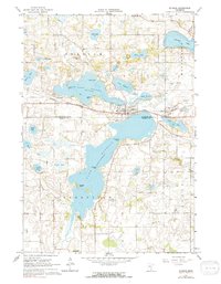
1966 Map of Elysian
USGS Topo · Published 1991About this map
Elysian serves as the central hub of this lakeside landscape, positioned on a narrow neck of land between Lake Francis and Lake Elysian. The area is defined by its glacial hydrology, where numerous named basins like Tetonka Lake, Fish Lake, and Steele Lake dot the terrain. The Chicago Great Western railroad cuts a straight path across the map, passing through the small settlement of Greenland and directly through Elysian, illustrating the era's reliance on rail for moving agricultural goods and connecting these lakeside communities.
Find a feature on this map
40 named features on this map. Tap any name to fly to it.
Don’t see what you’re looking for? This feature index may not catch every label — zoom into the map to look around manually.
Map Details
Editions of this 1966 Elysian Map
2 editions found
Other maps of this area

1950 · Mankato East
USGS Topo · 1:62,500

1951 · Mankato East
USGS Topo · 1:62,500

1953 · Saint Paul
USGS Topo · 1:250,000

1959 · Saint Paul
USGS Topo · 1:250,000

1965 · Cleveland
USGS Topo · 1:24,000

1966 · Waseca
USGS Topo · 1:24,000

1966 · Janesville
USGS Topo · 1:24,000

1966 · Waterville
USGS Topo · 1:24,000

1966 · Cordova
USGS Topo · 1:24,000

1966 · Elysian
USGS Topo · 1:24,000