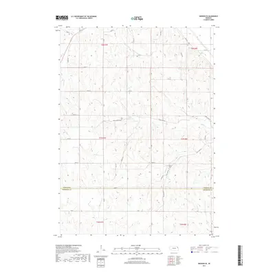
2017 Map of Emerson SE
USGS Topo · Published 2017About this map
The rolling agricultural divide between Dakota Co and Thurston Co is defined by a dense network of creek valleys and section-line roads. Several small burial grounds, including Taylor Cem in the north and Meseal Cem to the south, provide critical landmarks for genealogists and local historians tracking early families in this rural corridor. The drainage patterns of the region are dominated by Pigeon Cr and its engineered Pigeon Cr Ditch, alongside Fiddlers Cr and Wigie Cr, reflecting the long-standing management of water for farming. The landscape is dotted with several named springs and cemeteries, such as Baird Spring and Grove Cem, which offer physical evidence of the original homestead patterns and rural community hubs that shaped these two counties during the twentieth century.
Find a feature on this map
37 named features on this map. Tap any name to fly to it.
Don’t see what you’re looking for? This feature index may not catch every label — zoom into the map to look around manually.
Map Details
Editions of this 2017 Emerson SE Map
This is the sole edition of this map. No revisions or reprints were ever made.
Other maps of this area

1955 · Sioux City
USGS Topo · 1:250,000

1958 · Sioux City
USGS Topo · 1:250,000

1959 · Sioux City
USGS Topo · 1:250,000

1963 · Sioux City South
USGS Topo · 1:24,000

1964 · Homer
USGS Topo · 1:24,000

1966 · Walthill
USGS Topo · 1:24,000

1966 · Thurston
USGS Topo · 1:24,000

1966 · Pender NE
USGS Topo · 1:24,000

1967 · Waterbury
USGS Topo · 1:24,000
1967 · Jackson
USGS Topo · 1:24,000