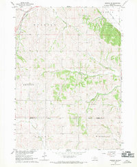
1967 Map of Emerson SE
USGS Topo · Published 1969About this map
The Winnebago Indian Reservation occupies the southern portion of this landscape, where the Dakota Co Thurston Co boundary line divides the rolling Nebraska terrain. This late-1960s survey documents a predominantly rural agricultural district punctuated by family-named landmarks and essential local institutions. Several small burial grounds, including Taylor Cem, Grove Cem, and Green Valley Cem, are scattered across the landscape, providing vital points of interest for genealogical research. The Chicago and North Western railroad cuts through the northwestern corner, following the path of Pigeon Creek. The hydrology of the area is well-defined by numerous waterways such as West Creek, Jones Creek, and Fiddlers Creek, which weave through the townships of Hubbard, Emerson, Merry, and Winnebago. A distinctive Baird Spring and a local Quarry further characterize the physical geography of this corner of northeast Nebraska.
Find a feature on this map
23 named features on this map. Tap any name to fly to it.
Don’t see what you’re looking for? This feature index may not catch every label — zoom into the map to look around manually.
Map Details
Editions of this 1967 Emerson SE Map
This is the sole edition of this map. No revisions or reprints were ever made.
Other maps of this area

1955 · Sioux City
USGS Topo · 1:250,000

1958 · Sioux City
USGS Topo · 1:250,000

1959 · Sioux City
USGS Topo · 1:250,000

1963 · Sioux City South
USGS Topo · 1:24,000

1964 · Homer
USGS Topo · 1:24,000

1966 · Walthill
USGS Topo · 1:24,000

1966 · Thurston
USGS Topo · 1:24,000

1966 · Pender NE
USGS Topo · 1:24,000

1967 · Waterbury
USGS Topo · 1:24,000
1967 · Jackson
USGS Topo · 1:24,000