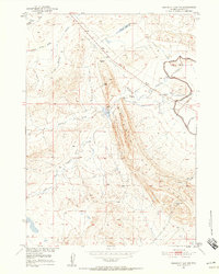
1951 Map of Emigrant Gap NW
USGS Topo · Published 1958About this map
Emigrant Gap Ridge dominates this Natrona County landscape, serving as a prominent topographic spine between the high plains and the drainage of South Fork Casper Creek. This mid-century survey, published as part of the Missouri River Basin development program, documents a complex network of water management features essential to the region's ranching and agricultural economy. The presence of the Casper Canal, several levees, and multiple segments of Casper Ditch (Aban'd) reveals the evolution of local irrigation and water rights. In the southern portion of the quadrangle, Hot Springs and Tudor Draw indicate natural water sources, while scattered windmills signify the ongoing effort to sustain livestock across the arid draws and gulches, including Clarks Gulch and Tie Bridge Gulch. Industrial history is noted by the inclusion of a Gravel Pit (Aban'd) and a regional Pipe Line cutting diagonally across the northern sections.
Find a feature on this map
21 named features on this map. Tap any name to fly to it.
Don’t see what you’re looking for? This feature index may not catch every label — zoom into the map to look around manually.
Map Details
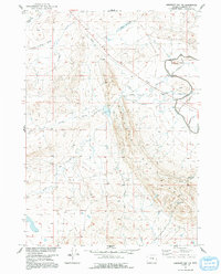
Editions of this 1951 Emigrant Gap NW Map
3 editions found
Other maps of this area

1950 · Emigrant Gap
USGS Topo · 1:24,000

1950 · Emigrant Gap NE
USGS Topo · 1:24,000

1951 · Oil Mountain
USGS Topo · 1:24,000

1951 · Emigrant Gap NW
USGS Topo · 1:24,000

1951 · Poison Spider
USGS Topo · 1:24,000

1951 · Reid Canyon
USGS Topo · 1:24,000

1955 · Arminto
USGS Topo · 1:250,000

1955 · Casper
USGS Topo · 1:250,000

1958 · Casper
USGS Topo · 1:250,000

1958 · Arminto
USGS Topo · 1:250,000