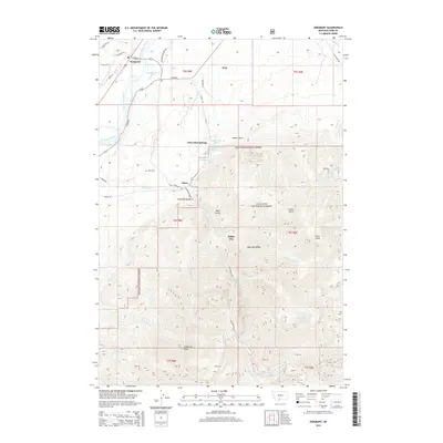
2014 Map of Emigrant
USGS Topo · Published 2014About this map
Chico Hot Springs and the surrounding settlement of Chico anchor this 2014 study of the Paradise Valley corridor. The landscape is dominated by the transition from the Yellowstone River valley floor into the high elevations of the Absaroka Range, where Emigrant Peak and Chico Peak provide dramatic topographic relief. The map documents the scattered residential patterns around Pray and White City, along with the critical water resources flowing from the mountains, including Emigrant Cr and Mill Cr. Cultural markers such as the Chico Cem provide vital reference points for genealogists researching family history in the Gallatin National Forest region. The intricate network of local roads like Emigrant Creek Rd and E River Rd illustrates the modern access to these historic mountain foothills.
Find a feature on this map
54 named features on this map. Tap any name to fly to it.
Don’t see what you’re looking for? This feature index may not catch every label — zoom into the map to look around manually.
Map Details
Editions of this 2014 Emigrant Map
This is the sole edition of this map. No revisions or reprints were ever made.
Other maps of this area

1891 · Livingston
USGS Topo · 1:250,000

1893 · Livingston
USGS Topo · 1:250,000

1947 · Bozeman
USGS Topo · 1:250,000

1948 · Bozeman
USGS Topo · 1:250,000

1955 · Bozeman
USGS Topo · 1:250,000

1955 · Emigrant
USGS Topo · 1:62,500

1955 · Fridley Peak
USGS Topo · 1:62,500
1955 · Gardiner
USGS Topo · 1:62,500
1955 · Miner
USGS Topo · 1:62,500

1958 · Bozeman
USGS Topo · 1:250,000