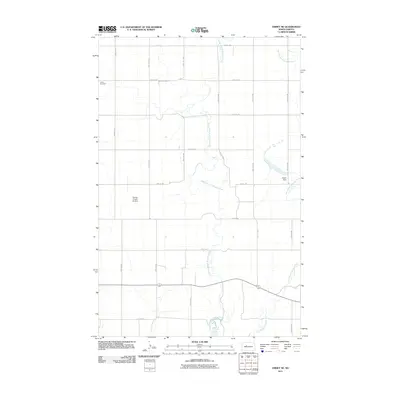
2011 Map of Emmet NE
USGS Topo · Published 2011About this map
Middle Branch Douglas Creek and East Branch Douglas Creek dictate the geography of this rural North Dakota landscape in McLean County. The terrain is characterized by a structured grid of agricultural section lines, including 48th Ave NW and 22nd St NW, which serve the scattered farmsteads of the region. Local history is anchored by the Clifton Cemetery in the northwest corner, a significant landmark for genealogical research in this sparsely populated area. The presence of the Fischer Private Airstrip and Hager Dam illustrates the specialized land use and water management necessary for large-scale prairie farming during the early 21st century. As a relatively feature-sparse quadrangle, the map highlights the immense space and systematic organization of the American High Plains, where most activity follows the major thoroughfares like County Hwy 11.
Find a feature on this map
22 named features on this map. Tap any name to fly to it.
Don’t see what you’re looking for? This feature index may not catch every label — zoom into the map to look around manually.
Map Details
Editions of this 2011 Emmet NE Map
This is the sole edition of this map. No revisions or reprints were ever made.
Other maps of this area
1922 · Garrison
USGS Topo · 1:62,500
1954 · McClusky
USGS Topo · 1:250,000
1956 · Emmet NE
USGS Topo · 1:24,000
1956 · Blue Hill
USGS Topo · 1:24,000
1956 · Emmet
USGS Topo · 1:24,000
1956 · Douglas West
USGS Topo · 1:24,000
1958 · McClusky
USGS Topo · 1:250,000
1967 · Emmet SE
USGS Topo · 1:24,000
1967 · Emmet SW
USGS Topo · 1:24,000
1972 · Garrison Dam North
USGS Topo · 1:24,000