
1967 Map of Emmet SE
USGS Topo · Published 1969About this map
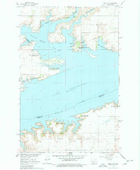
Lake Sakakawea dominates this 1967 landscape, shown at its normal pool elevation of 1838 feet. This mid-century survey illustrates the dramatic transformation of the Missouri River valley in McLean and Mercer counties following the completion of the Garrison Dam. The waters have filled Douglas Creek Bay, creating a complex shoreline that borders the Douglas Creek State Game Management Area and the Hille State Game Management Area.
Find a feature on this map
20 named features on this map. Tap any name to fly to it.
Don’t see what you’re looking for? This feature index may not catch every label — zoom into the map to look around manually.
Map Details
Editions of this 1967 Emmet SE Map
2 editions found
Other maps of this area

1922 · Garrison
USGS Topo · 1:62,500

1948 · Stanton
USGS Topo · 1:62,500

1949 · Stanton
USGS Topo · 1:62,500

1954 · McClusky
USGS Topo · 1:250,000

1956 · Emmet NE
USGS Topo · 1:24,000

1956 · Emmet
USGS Topo · 1:24,000

1958 · McClusky
USGS Topo · 1:250,000

1967 · Emmet SW
USGS Topo · 1:24,000

1969 · Hazen NE
USGS Topo · 1:24,000
1969 · Hazen NW
USGS Topo · 1:24,000