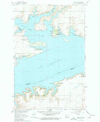
1967 Map of Emmet SE
USGS Topo · Published 1978About this map
The Missouri River corridor in McLean and Mercer Counties is defined here by the massive waters of Lake Sakakawea following the mid-century development of the Missouri River Basin. This survey documents a landscape of public lands and conservation efforts, including the Douglas Creek State Game Management Area and Hille State Game Management Area. The map captures the legacy of the western frontier through the Old Fort Stevenson Military Reservation Boundary, while showing the mid-1960s social landscape at Triangle Y Camp and a nearby Bible Camp. Genealogists may find the Geminde Cem and another uncaptioned Cem useful for family research in this sparsely populated region. The shoreline is highly articulated by the flooding of Douglas Creek and its branches, creating the prominent Douglas Creek Bay.
Find a feature on this map
20 named features on this map. Tap any name to fly to it.
Don’t see what you’re looking for? This feature index may not catch every label — zoom into the map to look around manually.
Map Details
Editions of this 1967 Emmet SE Map
2 editions found
Other maps of this area

1922 · Garrison
USGS Topo · 1:62,500

1948 · Stanton
USGS Topo · 1:62,500

1949 · Stanton
USGS Topo · 1:62,500

1954 · McClusky
USGS Topo · 1:250,000

1956 · Emmet NE
USGS Topo · 1:24,000

1956 · Emmet
USGS Topo · 1:24,000

1958 · McClusky
USGS Topo · 1:250,000

1967 · Emmet SE
USGS Topo · 1:24,000

1967 · Emmet SW
USGS Topo · 1:24,000

1969 · Hazen NE
USGS Topo · 1:24,000