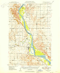
1949 Map of Stanton
USGS Topo · Published 1949About this map
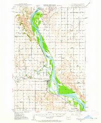
The Missouri River carves a wide path through this North Dakota landscape during a period of massive engineering, most notably with the Garrison Dam (Under Construction) near Riverdale. The sheet documents the Missouri River valley just before the completion of the dam would permanently alter the surrounding hydrology. Along the western banks, the town of Stanton serves as a hub, connected to the Northern Pacific railroad and supported by local industry such as a nearby Coal Mine.
Find a feature on this map
40 named features on this map. Tap any name to fly to it.
Don’t see what you’re looking for? This feature index may not catch every label — zoom into the map to look around manually.
Map Details
Editions of this 1949 Stanton Map
This is the sole edition of this map. No revisions or reprints were ever made.
Historical Maps of Stanton Through Time
8 maps found