
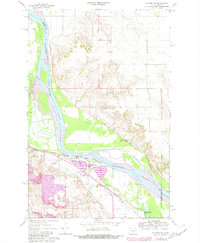
1967 Map of Stanton SE
USGS Topo · Published 1969About this map
The Missouri River corridor in central North Dakota reveals a landscape of deep historical significance and mid-century industrial expansion. This 1960s survey documents the juxtaposition of preserved frontier history at Fort Mandan Historic Site and Fort Clark Historic Site against a modernizing energy infrastructure. Near the confluence with the Knife River, an extensive industrial complex has taken shape, featuring a Powerplant, Substation, and large Settling Ponds. Local transport and industry are further marked by the Northern Pacific railroad line and a series of Gravel Pits along the river bluffs. Small family landmarks like Basto Cem and Alderin Cem remain on the higher ground, while the Trailer Park near the river bend suggests the mobile workforce associated with the area's development during this era.
Find a feature on this map
24 named features on this map. Tap any name to fly to it.
Don’t see what you’re looking for? This feature index may not catch every label — zoom into the map to look around manually.
Map Details
Editions of this 1967 Stanton SE Map
2 editions found
Other maps of this area

1948 · Stanton
USGS Topo · 1:62,500

1949 · Stanton
USGS Topo · 1:62,500

1949 · Washburn
USGS Topo · 1:62,500

1954 · McClusky
USGS Topo · 1:250,000

1958 · McClusky
USGS Topo · 1:250,000

1961 · Underwood
USGS Topo · 1:24,000

1967 · Washburn SW
USGS Topo · 1:24,000

1968 · Hannover NE
USGS Topo · 1:24,000

1968 · Fort Clark
USGS Topo · 1:24,000

1968 · Stanton
USGS Topo · 1:24,000