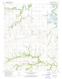
1973 Map of Emporia SE
USGS Topo · Published 1975About this map
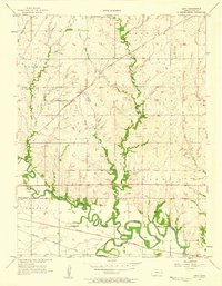
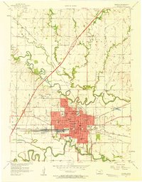
The confluence of the Cottonwood River and the Neosho River defines this landscape in Lyon County, where the massive John Redmond Reservoir and the Flint Hills National Wildlife Refuge dominate the northern terrain. The map captures a moment when large-scale water management and conservation were firmly established, yet the rural character of the southern townships remains evident through its network of creeks and small local landmarks. Genealogists will find particular value in the documentation of the Chicago Mound Cem and Mennonite Cem, alongside the Twin Mounds Ch near the distinctive Twin Mounds formation. Industrial activity is visible in the northeast through several Gravel Pits, while the southern half of the quadrangle is defined by the winding paths of Eagle Creek, South Creek, and Hoosier Creek.
Find a feature on this map
18 named features on this map. Tap any name to fly to it.
Don’t see what you’re looking for? This feature index may not catch every label — zoom into the map to look around manually.
Map Details
Editions of this 1973 Emporia SE Map
This is the sole edition of this map. No revisions or reprints were ever made.
Other maps of this area

1885 · Burlington
USGS Topo · 1:125,000

1888 · Emporia
USGS Topo · 1:125,000

1894 · Emporia
USGS Topo · 1:125,000

1894 · Burlington
USGS Topo · 1:125,000

1947 · Lawrence
USGS Topo · 1:250,000

1950 · Lawrence
USGS Topo · 1:250,000

1955 · Hutchinson
USGS Topo · 1:250,000

1956 · Lawrence
USGS Topo · 1:250,000
1957 · Lang
USGS Topo · 1:24,000
1957 · Emporia
USGS Topo · 1:24,000