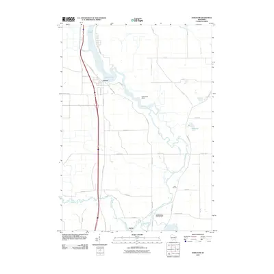
2010 Map of Endeavor
USGS Topo · Published 2010About this map
Endeavor sits at a strategic bend where the Fox River widens into the expansive Buffalo Lake, serving as a central point for this 2010 survey of Marquette County. The landscape is defined by the intricate waterways and marshlands of the French Creek Wildlife Refuge, where the French Creek Wildlife Refuge 2WP1497 Dam regulates the flow of French Creek before it joins the main river channel. This era of the map shows a mix of concentrated settlement and sprawling natural preserves.
Find a feature on this map
42 named features on this map. Tap any name to fly to it.
Don’t see what you’re looking for? This feature index may not catch every label — zoom into the map to look around manually.
Map Details
Editions of this 2010 Endeavor Map
This is the sole edition of this map. No revisions or reprints were ever made.
Other maps of this area

1902 · Portage
USGS Topo · 1:62,500

1902 · Briggsville
USGS Topo · 1:62,500

1957 · Madison
USGS Topo · 1:250,000

1958 · Briggsville
USGS Topo · 1:62,500

1960 · Madison
USGS Topo · 1:250,000

1961 · Oxford
USGS Topo · 1:62,500

1961 · Montello
USGS Topo · 1:62,500

1962 · Portage
USGS Topo · 1:62,500
1975 · Pine Island
USGS Topo · 1:24,000
1975 · Briggsville
USGS Topo · 1:24,000