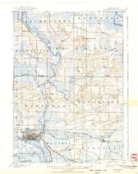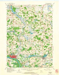
1962 Map of Portage
USGS Topo · Published 1964About this map
Portage serves as a critical junction in this early 1960s survey, situated where the Wisconsin River and Fox River nearly meet. The landscape is defined by the historical portage path and a complex network of waterways, including Buffalo Lake, Swan Lake, and Dates Millpond. The area's mid-century character is evident in the rail infrastructure of the Chicago Milwaukee St Paul and Pacific and the Chicago and North Western lines. Local heritage is preserved through numerous family and community sites like the Old Fort Winnebago Cem, Muir Memorial Park, and several country schools such as Dumke Sch and Marcellon Sch. The terrain rises at Observatory Hill and Madden Lakes, while the economy is marked by scattered Gravel Pits and the growth of communities like Pardeeville and Wyocena.
Find a feature on this map
87 named features on this map. Tap any name to fly to it.
Don’t see what you’re looking for? This feature index may not catch every label — zoom into the map to look around manually.
Map Details
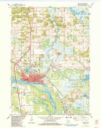
Editions of this 1962 Portage Map
This is the sole edition of this map. No revisions or reprints were ever made.
Historical Maps of Portage Through Time
8 maps found