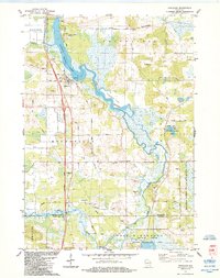
1984 Map of Endeavor
USGS Topo · Published 1984About this map
The village of Endeavor serves as a focal point along the western shores of Buffalo Lake, a prominent widening of the Fox River in Marquette County. This mid-1980s landscape is defined by the intersection of water and transport, with the Chicago and North Western railroad corridor and the developed residential area of Buffalo Shore Estates marking the era's growth. To the east, the terrain becomes more conservation-oriented, featuring the John Muir Memorial County Park surrounding Ennis Lake. The map details the transition into Columbia County at the southern border, where the settlement of Anacker and the sprawling French Creek State Wildlife Area dominate the wetlands. Local history is anchored by rural landmarks such as the Moundville Ch and the Rood Cem near the riverbanks.
Find a feature on this map
35 named features on this map. Tap any name to fly to it.
Don’t see what you’re looking for? This feature index may not catch every label — zoom into the map to look around manually.
Map Details
Editions of this 1984 Endeavor Map
This is the sole edition of this map. No revisions or reprints were ever made.
Other maps of this area

1902 · Portage
USGS Topo · 1:62,500

1902 · Briggsville
USGS Topo · 1:62,500

1957 · Madison
USGS Topo · 1:250,000

1958 · Briggsville
USGS Topo · 1:62,500

1960 · Madison
USGS Topo · 1:250,000

1961 · Oxford
USGS Topo · 1:62,500

1961 · Montello
USGS Topo · 1:62,500

1962 · Portage
USGS Topo · 1:62,500
1975 · Pine Island
USGS Topo · 1:24,000
1975 · Briggsville
USGS Topo · 1:24,000