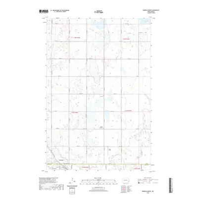
2020 Map of Enderlin North
USGS Topo · Published 2020About this map
The Maple River meanders across this rural landscape at the intersection of Cass and Ransom counties, defining the character of the terrain just north of the community of Enderlin. This 2020 survey documents a region of organized section lines and agricultural expanses, punctuated by small-scale aviation sites like Sky Haven Airport and Geske Airfield. For those researching local heritage, the map identifies significant focal points such as Salem Cem and the Pontiac Lutheran Trinity Cem, which serve as long-standing landmarks for the surrounding farming townships. The northern portion of the quadrangle is marked by wetland depressions and Lake Bertha, showing the glacial geography typical of this part of North Dakota. Modern infrastructure is represented by a grid of numbered roads, including Co RD 16 and Co RD 38, which connect the scattered homesteads to the primary hub at Enderlin.
Find a feature on this map
34 named features on this map. Tap any name to fly to it.
Don’t see what you’re looking for? This feature index may not catch every label — zoom into the map to look around manually.
Map Details
Editions of this 2020 Enderlin North Map
This is the sole edition of this map. No revisions or reprints were ever made.
Other maps of this area

1895 · Casselton
USGS Topo · 1:125,000

1897 · Tower
USGS Topo · 1:125,000

1897 · Casselton
USGS Topo · 1:125,000

1953 · Fargo
USGS Topo · 1:250,000

1956 · Fargo
USGS Topo · 1:250,000

1960 · Enderlin South
USGS Topo · 1:24,000
1960 · Sheldon
USGS Topo · 1:24,000

1961 · Sheldon NW
USGS Topo · 1:24,000

1961 · Enderlin North
USGS Topo · 1:24,000

1965 · Alice
USGS Topo · 1:24,000