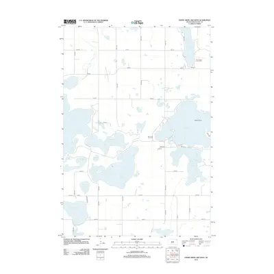
2012 Map of Enemy Swim Lake West
USGS Topo · Published 2012About this map
Glacial waters dominate this landscape in Day County, where the sprawling basins of Enemy Swim Lake and Waubay Lake meet a complex network of wetlands and smaller ponds. The shoreline of Pickerel Lake to the northeast reveals the small settlement of South End, while the interior of the quadrangle is defined by significant sloughs and ponds, including Dahling Slough and Phragmites Pond. This area represents a critical intersection of natural hydrology and indigenous history, evidenced by the presence of the Saint James Indian Cem near the western shores of Enemy Swim Lake. Local family and community roots are further anchored by the Saint Joseph's Catholic Cem near the north end of the sheet. The map details a transition from open water bodies like Minnewasta Lake and Hillebrands Lake to the structured grid of rural roads and lake access points that facilitate travel through this water-rich prairie region.
Find a feature on this map
38 named features on this map. Tap any name to fly to it.
Don’t see what you’re looking for? This feature index may not catch every label — zoom into the map to look around manually.
Map Details
Editions of this 2012 Enemy Swim Lake West Map
This is the sole edition of this map. No revisions or reprints were ever made.
Other maps of this area

1953 · Milbank
USGS Topo · 1:250,000

1958 · Milbank
USGS Topo · 1:250,000

1970 · Eden
USGS Topo · 1:24,000

1970 · Waubay
USGS Topo · 1:24,000

1970 · Piyas Lake
USGS Topo · 1:24,000

1970 · Enemy Swim Lake East
USGS Topo · 1:24,000

1970 · Waubay SW
USGS Topo · 1:24,000

1970 · Roslyn
USGS Topo · 1:24,000

1970 · Ortley
USGS Topo · 1:24,000

1970 · Drywood Lakes
USGS Topo · 1:24,000