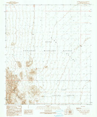
1990 Map of Engesser Pass SW
USGS Topo · Published 1990About this map
The Castle Dome Mountains dominate the western landscape of this desert terrain, where the peaks overlook the expansive King Valley. By the late twentieth century, this area of Yuma County was defined by its dual roles as a protected natural space and a military training site. The boundary of the Kofa National Wildlife Refuge encompasses much of the northern and central map area, while the southern portion transition into the Yuma Proving Ground. Scattered throughout the foothills of the range are numerous mining traces, specifically marked as Prospect, Prospects, and Mine Shafts Adits, indicating historical mineral exploration. Isolated water sources like Middle Well and Burnt Wagon Tank provide critical orientation points in an otherwise arid and sparsely developed environment.
Find a feature on this map
12 named features on this map. Tap any name to fly to it.
Don’t see what you’re looking for? This feature index may not catch every label — zoom into the map to look around manually.
Map Details
Editions of this 1990 Engesser Pass SW Map
This is the sole edition of this map. No revisions or reprints were ever made.
Other maps of this area

1928 · Norton
USGS Topo · 1:62,500

1929 · Norton
USGS Topo · 1:62,500

1942 · Yuma
USGS Topo · 1:250,000

1942 · Blythe
USGS Topo · 1:250,000

1942 · Vicksburg
USGS Topo · 1:250,000

1953 · Ajo
USGS Topo · 1:250,000

1954 · El Centro
USGS Topo · 1:250,000

1954 · Salton Sea
USGS Topo · 1:250,000

1954 · Phoenix
USGS Topo · 1:250,000

1955 · Salton Sea
USGS Topo · 1:250,000