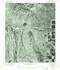
1971 Map of Enid
USGS Topo · Published 1972About this map
The settlement of Enid is situated along the east-west rail line that cuts through this arid landscape in the early 1970s. This orthophotomap provides a clear aerial perspective on the relationship between water and habitation in the desert, showing the intricate network of dry washes that drain the Palo Verde terrain. To the east, a stark transition occurs where the natural drainage patterns of the desert floor give way to the rigid, geometric grid of irrigated agricultural fields. This distinct boundary highlights the mid-century expansion of cultivation into the Arizona desert, made possible by managed water systems that contrast sharply with the alluvial fans and scattered brush shown elsewhere on the sheet.
Find a feature on this map
2 named features on this map. Tap any name to fly to it.
Don’t see what you’re looking for? This feature index may not catch every label — zoom into the map to look around manually.
Map Details
Editions of this 1971 Enid Map
This is the sole edition of this map. No revisions or reprints were ever made.
Other maps of this area

1913 · Maricopa
USGS Topo · 1:62,500

1915 · Maricopa
USGS Topo · 1:62,500

1946 · Antelope Peak
USGS Topo · 1:62,500

1948 · Antelope Peak
USGS Topo · 1:62,500

1951 · Estrella
USGS Topo · 1:62,500

1951 · Mobile
USGS Topo · 1:62,500

1952 · Maricopa
USGS Topo · 1:24,000
1952 · Pima Butte
USGS Topo · 1:24,000

1952 · Montezuma Peak
USGS Topo · 1:24,000

1952 · Enid
USGS Topo · 1:24,000