
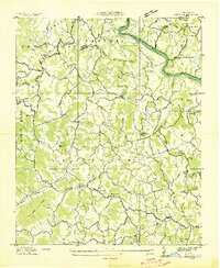
1936 Map of Enka
USGS Topo · Published 1936About this map
Enka and the surrounding Buncombe County landscape are captured here during a period of significant industrial and educational development in the mid-1930s. The presence of the Pisgah Industrial Institute and Christian Sch north of the Southern railroad line indicates a focused effort on local vocational training during this era. The industrial footprint of the Enka plant is clearly visible near Enka Lake, marking the transition of the Hominy Creek valley from a purely agrarian setting to a manufacturing hub.
Find a feature on this map
84 named features on this map. Tap any name to fly to it.
Don’t see what you’re looking for? This feature index may not catch every label — zoom into the map to look around manually.
Map Details
Editions of this 1936 Enka Map
This is the sole edition of this map. No revisions or reprints were ever made.
Other maps of this area

1894 · Asheville
USGS Topo · 1:125,000

1901 · Asheville
USGS Topo · 1:125,000

1905 · Pisgah
USGS Topo · 1:125,000

1906 · Pisgah
USGS Topo · 1:125,000

1935 · Cruso
USGS Topo · 1:24,000

1935 · Canton
USGS Topo · 1:24,000

1936 · Sandymush
USGS Topo · 1:24,000

1936 · Weaverville
USGS Topo · 1:24,000

1936 · Skyland
USGS Topo · 1:24,000
1936 · Leicester
USGS Topo · 1:24,000