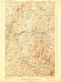
1924 Map of Enosburg Falls
USGS Topo · Published 1924About this map
Lake Carmi and the winding Missisquoi River define the landscape of northern Franklin County, just south of the Canada-United States border. In the early 1920s, the region was a bustling network of small farming hamlets and industrial outposts connected by the Central Vermont railroad. The village of Enosburg Falls serves as a primary hub, while specialized industry is noted at Gilberts Tannery near Enosburg Center.
Find a feature on this map
105 named features on this map. Tap any name to fly to it.
Don’t see what you’re looking for? This feature index may not catch every label — zoom into the map to look around manually.
Map Details
Editions of this 1924 Enosburg Falls Map
5 editions found
Other maps of this area

1913 · Milton
USGS Topo · 1:48,000

1914 · St. Albans
USGS Topo · 1:48,000

1915 · Milton
USGS Topo · 1:62,500

1916 · St. Albans
USGS Topo · 1:62,500

1919 · Montgomery
USGS Topo · 1:62,500

1920 · Franklin Pond
USGS Topo · 1:62,500

1920 · Montgomery
USGS Topo · 1:62,500

1922 · Enosburg Falls
USGS Topo · 1:48,000

1924 · Enosburg Falls
USGS Topo · 1:62,500

1925 · Jay Peak
USGS Topo · 1:62,500