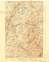
1924 Map of Enosburg Falls
USGS Topo · Published 1943About this map
Lake Carmi and the winding Missisquoi River dominate this northern Vermont landscape near the international border. In the early 1920s, the region was defined by a dense network of small rural schoolhouses like the Pomeroy School and Lost Nation School, which served a scattered agricultural population. Industrial hubs are concentrated along the river and rail lines, including Enosburg Falls and Sheldon Springs. The Central Vermont and St Johnsbury and Lake Champlain railroads intersect at Sheldon Junction, facilitating the transport of goods from local operations such as Gilberts Tannery. From the upland terrain of Little Pinnacle to the lowlands of Black Creek, the map captures a rural economy still heavily reliant on its waterways and rail connections before the dominance of modern highways.
Find a feature on this map
96 named features on this map. Tap any name to fly to it.
Don’t see what you’re looking for? This feature index may not catch every label — zoom into the map to look around manually.
Map Details
Editions of this 1924 Enosburg Falls Map
5 editions found
Other maps of this area

1913 · Milton
USGS Topo · 1:48,000

1914 · St. Albans
USGS Topo · 1:48,000

1915 · Milton
USGS Topo · 1:62,500

1916 · St. Albans
USGS Topo · 1:62,500

1919 · Montgomery
USGS Topo · 1:62,500

1920 · Franklin Pond
USGS Topo · 1:62,500

1920 · Montgomery
USGS Topo · 1:62,500

1922 · Enosburg Falls
USGS Topo · 1:48,000

1924 · Enosburg Falls
USGS Topo · 1:62,500

1925 · Jay Peak
USGS Topo · 1:62,500