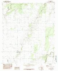
1984 Map of Eola
USGS Topo · Published 1984About this map
Eola sits at the heart of this West Texas landscape, positioned near the intersection of several key rural thoroughfares including 765 and 381. The terrain is defined by its drainage patterns, most notably the seasonal course of Dry Hollow which winds southward toward the settlement, and the larger Kickapoo Creek in the southeastern corner. Along the western edge, the map documents the boundary between Tom Green Co Concho Co, showing how local administrative lines correlate with the physical geography. Industrial footprints of the late 20th century are visible through several segments of a U G Pipeline and a localized Gravel Pit, suggesting a reliance on resource extraction and infrastructure. The map serves as a detailed record of land use in Concho County, where scattered buildings and windmills dot the plains around Lipan Creek.
Find a feature on this map
11 named features on this map. Tap any name to fly to it.
Don’t see what you’re looking for? This feature index may not catch every label — zoom into the map to look around manually.
Map Details
Editions of this 1984 Eola Map
This is the sole edition of this map. No revisions or reprints were ever made.
Other maps of this area

1891 · Hayrick
USGS Topo · 1:125,000

1892 · San Angelo
USGS Topo · 1:125,000

1892 · Eden
USGS Topo · 1:125,000

1892 · Ballinger
USGS Topo · 1:125,000

1894 · Hayrick
USGS Topo · 1:125,000

1896 · Eden
USGS Topo · 1:125,000

1921 · Lowake
USGS Topo · 1:31,680

1932 · Paint Rock
USGS Topo · 1:62,500

1954 · Brownwood
USGS Topo · 1:250,000

1954 · San Angelo
USGS Topo · 1:250,000