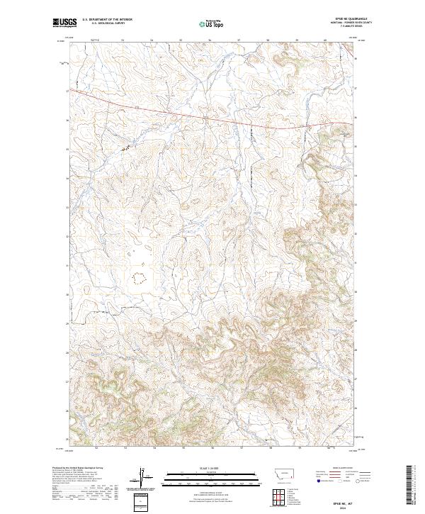
2024 Map of Epsie NE
USGS Topo · Published 2024About this map
West Fork Wolf Creek and East Fork Wolf Creek define the drainage patterns of this corner of Powder River County, where the landscape is carved by a complex network of ephemeral and perennial streams. The terrain is marked by significant elevation changes, most notably at Sand Creek Hill in the northeast, overlooking the headwaters of Sand Creek. The southern portion of the map reveals a rugged catchment area for Rough Creek and Wrangler Creek, showing the detailed topography of the southeastern Montana breaks. Transportation is limited to remote corridors like Moorehead Rd, which skirts the southern boundary, reflecting a territory dedicated to large-scale ranching and open range. This 2024 survey documents the enduring physical character of the land, from the secluded Dripping Spring Creek to the various forks that eventually feed the larger regional watersheds.
Find a feature on this map
14 named features on this map. Tap any name to fly to it.
Don’t see what you’re looking for? This feature index may not catch every label — zoom into the map to look around manually.
Map Details
Editions of this 2024 Epsie NE Map
This is the sole edition of this map. No revisions or reprints were ever made.
Other maps of this area

1954 · Ekalaka
USGS Topo · 1:250,000

1956 · Ekalaka
USGS Topo · 1:250,000

1958 · Ekalaka
USGS Topo · 1:250,000

1965 · Ekalaka
USGS Topo · 1:250,000

1973 · Olive
USGS Topo · 1:24,000

1973 · Lonesome Peak
USGS Topo · 1:24,000

1973 · Moonlight Creek
USGS Topo · 1:24,000
1973 · Yarger Butte
USGS Topo · 1:24,000
1973 · Eldon Mountain
USGS Topo · 1:24,000
1973 · Leslie Creek
USGS Topo · 1:24,000