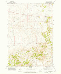
1973 Map of Epsie NE
USGS Topo · Published 1977About this map
Wolf Creek and its various tributaries define this remote corner of Powder River County, where the high plains transition into dissected breaks. In the early 1970s, the landscape remained largely defined by livestock grazing and mineral exploration, evidenced by the numerous drainage networks like the West Fork and East Fork. Local industry is anchored by small-scale mining operations, including the Peerless Mine near Sand Creek Hill and the Gatlin Mine further south. The presence of several Drill Holes across the quadrangle suggests ongoing subsurface investigation during this era. Transportation is limited to a sparse network of unimproved roads and a Jeep Trail, while the prominent Radio Tower near Sand Creek serves as a modern landmark in an otherwise unpopulated expanse of grazing land and watercourses such as Wrangler Creek and Rough Creek.
Find a feature on this map
15 named features on this map. Tap any name to fly to it.
Don’t see what you’re looking for? This feature index may not catch every label — zoom into the map to look around manually.
Map Details
Editions of this 1973 Epsie NE Map
This is the sole edition of this map. No revisions or reprints were ever made.
Other maps of this area

1954 · Ekalaka
USGS Topo · 1:250,000

1956 · Ekalaka
USGS Topo · 1:250,000

1958 · Ekalaka
USGS Topo · 1:250,000

1965 · Ekalaka
USGS Topo · 1:250,000

1973 · Olive
USGS Topo · 1:24,000

1973 · Lonesome Peak
USGS Topo · 1:24,000

1973 · Moonlight Creek
USGS Topo · 1:24,000
1973 · Yarger Butte
USGS Topo · 1:24,000
1973 · Eldon Mountain
USGS Topo · 1:24,000
1973 · Leslie Creek
USGS Topo · 1:24,000