
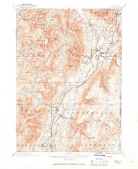
1894 Map of Equinox
USGS Topo · Published 1964About this map
The Batten Kill River valley serves as the central corridor for this late 19th-century survey of the Green Mountains, where agricultural settlements and early industry established themselves along the water's edge. This landscape is defined by its deep hollows and named peaks, including Mother Myrick Mtn. and Shatterack Mtn., which loom over concentrated villages like Manchester Center and Manchester Depot. The presence of the D. & H. R.R. in the northwestern corner at West Rupert highlights the era's reliance on rail for commerce, while smaller hamlets like Barnumville and Chiselville represent the local network of timber and farm economies. Notable for genealogists is the granular detail of family-named landmarks and remote locations like Kelley Stand and the settlement of Kansas, providing a clear look at the dispersed population patterns before the 20th century.
Find a feature on this map
101 named features on this map. Tap any name to fly to it.
Don’t see what you’re looking for? This feature index may not catch every label — zoom into the map to look around manually.
Map Details
Editions of this 1894 Equinox Map
2 editions found
Other maps of this area

1889 · Wilmington
USGS Topo · 1:62,500

1891 · Wilmington
USGS Topo · 1:62,500

1893 · Wallingford
USGS Topo · 1:62,500

1893 · Fort Ann
USGS Topo · 1:62,500

1894 · Londonderry
USGS Topo · 1:62,500

1894 · Pawlet
USGS Topo · 1:62,500

1895 · Cambridge
USGS Topo · 1:62,500

1895 · Fort Ann
USGS Topo · 1:62,500

1896 · Equinox
USGS Topo · 1:62,500

1897 · Pawlet
USGS Topo · 1:62,500