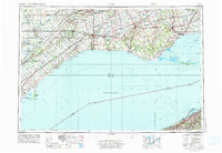
1959 Map of Erie
USGS Topo · Published 1974About this map
Lake Erie defines the character of this mid-century cross-border survey, illustrating the maritime and industrial connections between Southwestern Ontario and Pennsylvania. The Canadian shore is marked by extensive port settlements and conservation areas, including Rondeau Provincial Park and the long, sweeping reach of Long Point. Inland, a dense network of railroads such as the Canadian National and Canadian Pacific converges on London and St Thomas, supporting an agricultural and manufacturing corridor. On the southern shore, Erie serves as the primary American hub, anchored by its protected Erie Harbor and the sandspit of Presque Isle State Park. This period shows the region's established infrastructure before the full dominance of the modern highway system, highlighting the cultural geography of the Caradoc Indian Reserve and various family-named creeks like Catfish Creek and Kettle Creek.
Find a feature on this map
223 named features on this map. Tap any name to fly to it.
Don’t see what you’re looking for? This feature index may not catch every label — zoom into the map to look around manually.
Map Details
Editions of this 1959 Erie Map
2 editions found

Other maps of this area

1899 · Erie
USGS Topo · 1:62,500

1900 · Girard
USGS Topo · 1:62,500

1900 · Erie
USGS Topo · 1:62,500

1900 · Fairview
USGS Topo · 1:62,500

1905 · Ashtabula
USGS Topo · 1:62,500

1905 · Perry
USGS Topo · 1:62,500

1906 · Conneaut
USGS Topo · 1:62,500

1913 · North East
USGS Topo · 1:62,500

1915 · North East
USGS Topo · 1:62,500

1923 · Cambridge Springs
USGS Topo · 1:62,500