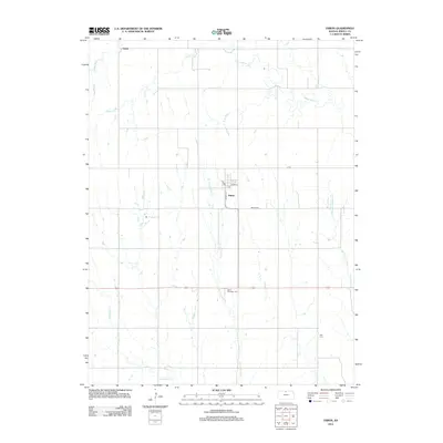
2012 Map of Esbon
USGS Topo · Published 2012About this map
The town of Esbon serves as the focal point of this Jewell County survey, situated at the junction of Grand Ave and Henry St. The surrounding agricultural landscape is defined by the dendritic drainage patterns of White Rock Cr, Smith Cr, and W Limestone Cr. To the north, the small community of Salem remains a notable landmark in this rural expanse. Local history and genealogy are anchored by several established burial grounds, including the Esbon Cem just east of town, the Saint Elizabeth Cem to the south, and the more isolated Zion Cem in the southeastern portion of the quadrangle. The map illustrates a grid-like road system typical of the Great Plains, where routes like S Rd and E St navigate the subtle shifts in elevation between the various creek basins.
Find a feature on this map
15 named features on this map. Tap any name to fly to it.
Don’t see what you’re looking for? This feature index may not catch every label — zoom into the map to look around manually.
Map Details
Editions of this 2012 Esbon Map
This is the sole edition of this map. No revisions or reprints were ever made.
Other maps of this area

1893 · Smith Center
USGS Topo · 1:125,000

1894 · Mankato
USGS Topo · 1:125,000

1955 · Beloit
USGS Topo · 1:250,000

1959 · Beloit
USGS Topo · 1:250,000
1968 · Burr Oak NW
USGS Topo · 1:24,000

1968 · Burr Oak
USGS Topo · 1:24,000
1969 · Ionia
USGS Topo · 1:24,000
1969 · Cawker City NW
USGS Topo · 1:24,000
1969 · North Branch
USGS Topo · 1:24,000
1969 · Esbon
USGS Topo · 1:24,000