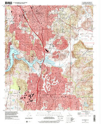
1996 Map of Escondido
USGS Topo · Published 2001About this map
The growing city of Escondido dominates the northern half of this landscape, while the planned communities of Rancho Bernardo and Poway expand to the south. The 1990s character of the region is defined by these burgeoning residential corridors, punctuated by landmarks like the Escondido Promenade and North County Fair. The rugged topography between these centers is dominated by the sprawling Lake Hodges and the heights of Bernardo Mtn and Battle Mtn, areas that remained largely undeveloped even as the suburban footprint moved toward the San Diego Wild Animal Park in the east.
Find a feature on this map
45 named features on this map. Tap any name to fly to it.
Don’t see what you’re looking for? This feature index may not catch every label — zoom into the map to look around manually.
Map Details
Editions of this 1996 Escondido Map
This is the sole edition of this map. No revisions or reprints were ever made.
Other maps of this area

1893 · El Cajon
USGS Topo · 1:62,500

1893 · Escondido
USGS Topo · 1:62,500

1901 · Elcajon
USGS Topo · 1:62,500

1901 · Escondido
USGS Topo · 1:62,500

1901 · San Luis Rey
USGS Topo · 1:125,000

1903 · Cuyamaca
USGS Topo · 1:125,000

1903 · La Jolla
USGS Topo · 1:62,500

1903 · Elcajon
USGS Topo · 1:62,500

1903 · Ramona
USGS Topo · 1:125,000

1904 · Southern California Sheet No. 2
USGS Topo · 1:250,000