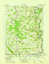
1946 Map of Esperance
USGS Topo · Published 1946About this map
Sloansville and Esperance anchor the southern reaches of this mid-1940s landscape, where the Cherry Valley Turnpike cuts a straight line across the rolling hills of Montgomery and Schoharie Counties. The map reveals a deeply established rural network of small crossroads such as Fox Corners, Market Corners, and Davis Corners, each serving as a local hub for the surrounding farmsteads. To the east, the Schoharie Creek meanders sharply through Lost Valley, its flow monitored at a Gaging Station near Burtonsville.
Find a feature on this map
41 named features on this map. Tap any name to fly to it.
Don’t see what you’re looking for? This feature index may not catch every label — zoom into the map to look around manually.
Map Details
Editions of this 1946 Esperance Map
This is the sole edition of this map. No revisions or reprints were ever made.
Other maps of this area

1895 · Amsterdam
USGS Topo · 1:62,500

1896 · Fonda
USGS Topo · 1:62,500

1898 · Fonda
USGS Topo · 1:62,500

1898 · Schoharie
USGS Topo · 1:62,500

1900 · Schoharie
USGS Topo · 1:62,500

1900 · Schoharie
USGS Topo · 1:31,680

1900 · Berne
USGS Topo · 1:62,500

1902 · Fonda
USGS Topo · 1:62,500

1903 · Berne
USGS Topo · 1:62,500

1931 · Amsterdam
USGS Topo · 1:62,500