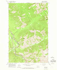
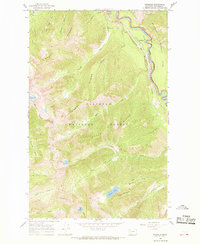
1964 Map of Essex
USGS Topo · Published 1966About this map
Essex serves as a small but vital hub in the mid-1960s where the Great Northern Railway tracks follow the winding course of the Middle Fork Flathead River. This mountain landscape is defined by the sharp transition between the Glacier National Park boundary to the north and the Flathead National Forest to the south. The presence of the Essex PO and the nearby Walton Ranger Station indicates the settlement's role as a base for both forest management and railway operations near the continental divide.
Find a feature on this map
29 named features on this map. Tap any name to fly to it.
Don’t see what you’re looking for? This feature index may not catch every label — zoom into the map to look around manually.
Map Details
Editions of this 1964 Essex Map
This is the sole edition of this map. No revisions or reprints were ever made.
Other maps of this area

1913 · Marias Pass
USGS Topo · 1:125,000

1914 · Nyack
USGS Topo · 1:125,000
1958 · Nimrod
USGS Topo · 1:24,000
1958 · Mount Bradley
USGS Topo · 1:24,000
1958 · Felix Peak
USGS Topo · 1:24,000

1960 · Cut Bank
USGS Topo · 1:250,000

1963 · Cut Bank
USGS Topo · 1:250,000

1964 · Cut Bank
USGS Topo · 1:250,000
1964 · Pinnacle
USGS Topo · 1:24,000
1964 · Stanton Lake
USGS Topo · 1:24,000