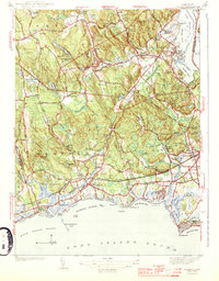
1944 Map of Essex
USGS Topo · Published 1944About this map
The coastal shoreline of Long Island Sound meets the lower Connecticut River valley in this 1939 survey of the Middlesex County region. The rail corridor of the New York New Haven and Hartford railroad bisects the landscape, connecting the industrial centers of Ivoryton and Centerbrook to the coastal transport hub at Old Saybrook. Along the coast, a dense string of seasonal and permanent settlements including Knollwood, Saybrook Manor, and Westbrook are defined by their proximity to public beaches like Quotonset Beach and Chalker Beach. Inland, the terrain is shaped by a complex network of reservoirs and ponds such as Pratt Reed Reservoir and Bushy Hill Pond, which supported the area's early manufacturing economy. Genealogists will find significant detail in the placement of civic anchors like the Winthrop School and Winthrop Church, alongside numerous burial grounds including Cypress Cem and Mill Meadows Cem.
Find a feature on this map
97 named features on this map. Tap any name to fly to it.
Don’t see what you’re looking for? This feature index may not catch every label — zoom into the map to look around manually.
Map Details
Editions of this 1944 Essex Map
3 editions found
Other maps of this area

1893 · Guilford
USGS Topo · 1:62,500

1893 · Saybrook
USGS Topo · 1:62,500

1941 · Lyme
USGS Topo · 1:31,680

1944 · Essex
USGS Topo · 1:31,680

1944 · Deep River
USGS Topo · 1:31,680
1947 · Orient
USGS Topo · 1:24,000

1947 · Hartford
USGS Topo · 1:250,000

1948 · Hartford
USGS Topo · 1:250,000
1951 · Lyme
USGS Topo · 1:31,680

1951 · Clinton
USGS Topo · 1:31,680