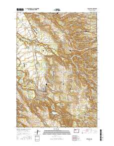
2017 Map of Estacada
USGS Topo · Published 2017About this map
Estacada sits at the heart of this landscape, where the Clackamas River meets a network of creeks and timber-focused infrastructure. The industrial footprint of the region is evident through features like the Milwaukie Plywood Corporation Log Pond and the extensive water management systems of Faraday Lake and Estacada Lake. Local history and genealogy are well-represented by several burial grounds, including the Forrester Cem, the Sandy Ridge Cem, and the Independent Order of Odd Fellows Cem near the town center. Small aviation strips such as Eagle Nest Ranch Airport, Beaver Oaks Airport, and Valley View Airport are scattered across the terrain, indicating a landscape where private flight was common alongside rural settlements. Moving away from the river valley, the topography rises toward Douglass Ridge and Mount Zion, while named settlements like Eagle Creek, Currinsville, and Springwater anchor the surrounding countryside.
Find a feature on this map
139 named features on this map. Tap any name to fly to it.
Don’t see what you’re looking for? This feature index may not catch every label — zoom into the map to look around manually.
Map Details
Editions of this 2017 Estacada Map
This is the sole edition of this map. No revisions or reprints were ever made.
Other maps of this area

1911 · Boring
USGS Topo · 1:48,000

1914 · Boring
USGS Topo · 1:62,500

1916 · Estacada
USGS Topo · 1:125,000

1940 · Boring
USGS Topo · 1:62,500

1948 · Vancouver
USGS Topo · 1:250,000

1950 · Vancouver
USGS Topo · 1:250,000

1950 · Vancouver
USGS Topo · 1:250,000
1954 · Damascus
USGS Topo · 1:24,000
1954 · Sandy
USGS Topo · 1:24,000
1954 · Redland
USGS Topo · 1:24,000