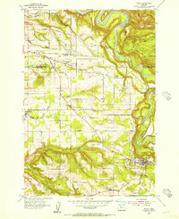
1954 Map of Sandy
USGS Topo · Published 1956About this map
Sandy River meanders through the eastern portion of this mid-1950s landscape, carved by deep ravines and the winding courses of Deep Creek and Tickle Creek. The geography reveals a transition from the agricultural plateaus of the west to the more broken terrain approaching the Mount Hood foothills. Small rural centers such as Orient, Cottrell, and Pleasant Home serve as focal points for the surrounding farmsteads, while the community of Boring sits at the southwestern edge. The map captures the area just as the Mt Hood Loop Highway was solidifying its role as a primary artery through Sandy, connecting the Willamette Valley to the Cascades.
Find a feature on this map
60 named features on this map. Tap any name to fly to it.
Don’t see what you’re looking for? This feature index may not catch every label — zoom into the map to look around manually.
Map Details
Editions of this 1954 Sandy Map
This is the sole edition of this map. No revisions or reprints were ever made.
Other maps of this area

1911 · Boring
USGS Topo · 1:48,000

1914 · Boring
USGS Topo · 1:62,500

1916 · Estacada
USGS Topo · 1:125,000

1918 · Troutdale
USGS Topo · 1:62,500

1934 · Troutdale
USGS Topo · 1:48,000

1940 · Boring
USGS Topo · 1:62,500

1941 · Camas
USGS Topo · 1:62,500

1942 · Camas
USGS Topo · 1:62,500

1948 · Vancouver
USGS Topo · 1:250,000

1950 · Vancouver
USGS Topo · 1:250,000