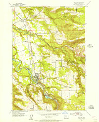
1954 Map of Estacada
USGS Topo · Published 1956About this map
The Clackamas River serves as the industrial and geographic spine of this mid-1950s survey of Clackamas County, powering the region through the River Mill Powerhouse and Cazadero Powerhouse. The town of Estacada is the central hub, surrounded by smaller settlements like Currinsville, Garfield, and Springwater. The map reveals a landscape defined by timber and transit, with several sawmills scattered across the drainages of Deep Creek and Eagle Creek.
Find a feature on this map
50 named features on this map. Tap any name to fly to it.
Don’t see what you’re looking for? This feature index may not catch every label — zoom into the map to look around manually.
Map Details
Editions of this 1954 Estacada Map
This is the sole edition of this map. No revisions or reprints were ever made.
Other maps of this area

1911 · Boring
USGS Topo · 1:48,000

1914 · Boring
USGS Topo · 1:62,500

1916 · Estacada
USGS Topo · 1:125,000

1940 · Boring
USGS Topo · 1:62,500

1948 · Vancouver
USGS Topo · 1:250,000

1950 · Vancouver
USGS Topo · 1:250,000

1950 · Vancouver
USGS Topo · 1:250,000
1954 · Damascus
USGS Topo · 1:24,000
1954 · Sandy
USGS Topo · 1:24,000
1954 · Redland
USGS Topo · 1:24,000