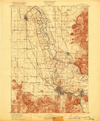
1910 Map of Eugene
USGS Topo · Published 1920About this map
Eugene and Springfield serve as the primary hubs in this early 20th-century landscape, connected by the waters of the Willamette River and the McKenzie River. The map reveals a complex river system with numerous channels and sloughs surrounding features like Marshall Island and Goodpasture Island. Prominent landmarks such as Skinner Butte and the University of Oregon are clearly established, while the surrounding valley is dotted with small rural communities and local education centers including the Santa Clara School and Bethel School.
Find a feature on this map
62 named features on this map. Tap any name to fly to it.
Don’t see what you’re looking for? This feature index may not catch every label — zoom into the map to look around manually.
Map Details
Editions of this 1910 Eugene Map
2 editions found
Other maps of this area

1909 · Harrisburg
USGS Topo · 1:31,680

1909 · Rowland
USGS Topo · 1:31,680

1909 · Elmira
USGS Topo · 1:62,500

1910 · Eugene
USGS Topo · 1:62,500

1911 · Monroe
USGS Topo · 1:31,680

1912 · Halsey
USGS Topo · 1:62,500

1921 · Brownsville
USGS Topo · 1:62,500

1921 · Cottage Grove
USGS Topo · 1:62,500

1922 · Monroe
USGS Topo · 1:62,500

1922 · Elmira
USGS Topo · 1:62,500