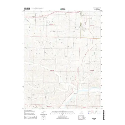
2015 Map of Eugene
USGS Topo · Published 2015About this map
Eugene and Etterville anchor this Miller County landscape where the Osage River winds past Coon Creek Island. The terrain is defined by a dense network of drainages including Little Saline Cr, Jim Henry Cr, and Little Tavern Cr, which cut through the Ozark foothills. This 2015 survey reveals a rural landscape dominated by county roads and family-named landmarks like Haynes Ranch Rd. Local history and genealogy are preserved at the Gageville Cemetery and Thompson Cemetery, while the county boundary between Miller Co and Cole Co bisects the northeastern corner. The distribution of creeks like Jack Buster Cr and Mack Buster Cr illustrates the deeply dissected nature of the hills surrounding the Osage, providing a detailed look at the local geography of the region.
Find a feature on this map
76 named features on this map. Tap any name to fly to it.
Don’t see what you’re looking for? This feature index may not catch every label — zoom into the map to look around manually.
Map Details
Editions of this 2015 Eugene Map
This is the sole edition of this map. No revisions or reprints were ever made.
Other maps of this area

1888 · Versailles
USGS Topo · 1:125,000

1888 · Tuscumbia
USGS Topo · 1:125,000

1893 · Versailles
USGS Topo · 1:125,000

1894 · Tuscumbia
USGS Topo · 1:125,000

1904 · Eldon
USGS Topo · 1:62,500

1932 · Versailles No 4
USGS Topo · 1:48,000

1933 · Iberia
USGS Topo · 1:62,500

1934 · Bagnell
USGS Topo · 1:24,000
1935 · Eldon
USGS Topo · 1:24,000

1937 · Iberia
USGS Topo · 1:62,500