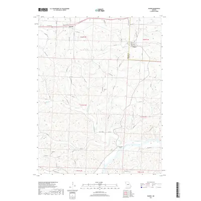
2017 Map of Eugene
USGS Topo · Published 2017About this map
The Osage River meanders through the southern portion of this Miller County landscape, defining a terrain dominated by winding creek valleys and ridges. Near the river's bend, Coon Creek Island sits at the confluence with Coon Creek. The settlement of Eugene is positioned in the northeast near the Cole County line, featuring a small street grid including Tunnel St and Market St. To the northwest, the community of Etterville serves as another focal point for local transit and history. For genealogists, the map identifies several burial sites, such as Gageville Cem and Thompson Cem, which are tucked away from the main thoroughfares. A complex network of waterways, including Saline Creek, Jim Henry Cr, and Little Tavern Cr, illustrates the drainage patterns that have long shaped the agricultural and residential development of this Missouri interior.
Find a feature on this map
76 named features on this map. Tap any name to fly to it.
Don’t see what you’re looking for? This feature index may not catch every label — zoom into the map to look around manually.
Map Details
Editions of this 2017 Eugene Map
This is the sole edition of this map. No revisions or reprints were ever made.
Other maps of this area

1888 · Versailles
USGS Topo · 1:125,000

1888 · Tuscumbia
USGS Topo · 1:125,000

1893 · Versailles
USGS Topo · 1:125,000

1894 · Tuscumbia
USGS Topo · 1:125,000

1904 · Eldon
USGS Topo · 1:62,500

1932 · Versailles No 4
USGS Topo · 1:48,000

1933 · Iberia
USGS Topo · 1:62,500

1934 · Bagnell
USGS Topo · 1:24,000
1935 · Eldon
USGS Topo · 1:24,000

1937 · Iberia
USGS Topo · 1:62,500