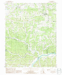
1987 Map of Eugene
USGS Topo · Published 1987About this map
The Osage River dominates the southern landscape of this 1987 survey, winding past Coon Creek Island and the neighboring Kings Bluff State Wildlife Area. The terrain is defined by a dense network of tributaries including Buster Creek, Jim Henry Creek, and Little Saline Creek, which carve through the rural countryside. Small settlements like Eugene and Etterville serve as local hubs, while Saline marks a quiet intersection near the Saline Valley State Wildlife Area. Numerous quarries scattered throughout the hills indicate local resource extraction, while the presence of a Fish Hatchery near the western edge reflects specialized land use. This provisional map captures the region's character as a mix of conservation land, river bottomlands, and small-scale upland agriculture, with the Wooden Pole Trans Line providing a notable piece of mid-century utility infrastructure.
Find a feature on this map
33 named features on this map. Tap any name to fly to it.
Don’t see what you’re looking for? This feature index may not catch every label — zoom into the map to look around manually.
Map Details
Editions of this 1987 Eugene Map
This is the sole edition of this map. No revisions or reprints were ever made.
Other maps of this area

1888 · Versailles
USGS Topo · 1:125,000

1888 · Tuscumbia
USGS Topo · 1:125,000

1893 · Versailles
USGS Topo · 1:125,000

1894 · Tuscumbia
USGS Topo · 1:125,000

1904 · Eldon
USGS Topo · 1:62,500

1932 · Versailles No 4
USGS Topo · 1:48,000

1933 · Iberia
USGS Topo · 1:62,500

1934 · Bagnell
USGS Topo · 1:24,000
1935 · Eldon
USGS Topo · 1:24,000

1937 · Iberia
USGS Topo · 1:62,500