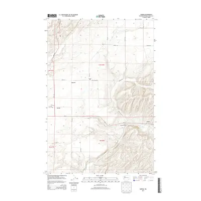
2013 Map of Eureka
USGS Topo · Published 2013About this map
The Touchet River winds through the southeastern corner of this Walla Walla County landscape, cutting a path near the small settlement of Lamar. Further north and west, the terrain transitions into the wide expanse of Eureka Flat, a region characterized by its agricultural potential and the small communities of Eureka and Babcock. The map highlights a network of local thoroughfares such as Alonzo Walker Rd and Eureka N Rd that link these rural outposts. To the north, the elevation rises toward Rice Hill and the community of Lee, while Winnett Canyon provides a distinct break in the topography near the river. This survey illustrates the relationship between the river valley and the higher plateau, showing the distribution of family-named roads and rural infrastructure that sustained these eastern Washington settlements into the early 21st century.
Find a feature on this map
25 named features on this map. Tap any name to fly to it.
Don’t see what you’re looking for? This feature index may not catch every label — zoom into the map to look around manually.
Map Details
Editions of this 2013 Eureka Map
This is the sole edition of this map. No revisions or reprints were ever made.
Other maps of this area

1915 · Wallulah
USGS Topo · 1:96,000

1918 · Wallula
USGS Topo · 1:125,000

1919 · Walla Walla
USGS Topo · 1:125,000

1921 · Walla Walla
USGS Topo · 1:125,000

1953 · Walla Walla
USGS Topo · 1:250,000

1958 · Walla Walla
USGS Topo · 1:250,000

1966 · Page
USGS Topo · 1:24,000

1966 · Snake River
USGS Topo · 1:24,000

1966 · Rulo
USGS Topo · 1:24,000

1966 · Hadley
USGS Topo · 1:24,000