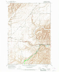
1966 Map of Eureka
USGS Topo · Published 1968About this map
Eureka Flat dominates the northwestern portion of this Walla Walla County survey, characterized by broad agricultural expanses and the critical infrastructure of the mid-1960s grain economy. The Northern Pacific railroad forms the backbone of the region's transport network, connecting the settlements of Eureka, Babcock, and Lee. Prominent Grain Elevators near the rail lines underscore the area's role as a wheat-growing hub, while a Landing Strip and Fire Station serve the local rural community. To the south, the landscape shifts dramatically as the terrain descends into the valley of the Touchet River near Lamar. This topographic transition is marked by the rugged incision of Winnett Canyon, illustrating the contrast between the high, level plateau lands and the riparian corridors that defined the movement of goods and people in eastern Washington.
Find a feature on this map
24 named features on this map. Tap any name to fly to it.
Don’t see what you’re looking for? This feature index may not catch every label — zoom into the map to look around manually.
Map Details
Editions of this 1966 Eureka Map
This is the sole edition of this map. No revisions or reprints were ever made.
Other maps of this area

1915 · Wallulah
USGS Topo · 1:96,000

1918 · Wallula
USGS Topo · 1:125,000

1919 · Walla Walla
USGS Topo · 1:125,000

1921 · Walla Walla
USGS Topo · 1:125,000

1953 · Walla Walla
USGS Topo · 1:250,000

1958 · Walla Walla
USGS Topo · 1:250,000

1966 · Page
USGS Topo · 1:24,000

1966 · Snake River
USGS Topo · 1:24,000

1966 · Rulo
USGS Topo · 1:24,000

1966 · Hadley
USGS Topo · 1:24,000