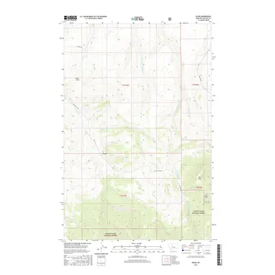
2017 Map of Evans
USGS Topo · Published 2017About this map
The Evans settlement serves as the focal point for this landscape in Cascade County, where the plains of central Montana begin their transition into the foothills. The terrain is defined by an intricate drainage system, with Sand Coulee Cr and its tributaries, including Middle Fork Sand Coulee Cr and E Fork Sand Coulee Cr, carving deep into the earth. To the south, the boundary of the Lewis & Clark National Forest encompasses more prominent topographical features like the distinctive Tiger Butte. This 2017 survey illustrates the intersection of public forest lands and private ranching territory, connected by a network of rural routes such as Evans Riceville Rd and Beckstrom Rd. Smaller watercourses like Half-Breed Cr and Bayes Coulee snake through the sections, tracing the natural contours of the high-country draws.
Find a feature on this map
24 named features on this map. Tap any name to fly to it.
Don’t see what you’re looking for? This feature index may not catch every label — zoom into the map to look around manually.
Map Details
Editions of this 2017 Evans Map
This is the sole edition of this map. No revisions or reprints were ever made.
Other maps of this area

1886 · Great Falls
USGS Topo · 1:250,000

1890 · Fort Benton
USGS Topo · 1:250,000

1892 · Fort Benton
USGS Topo · 1:250,000

1897 · Fort Benton
USGS Topo · 1:250,000

1954 · Great Falls
USGS Topo · 1:250,000

1955 · Stockett
USGS Topo · 1:62,500

1956 · Belt
USGS Topo · 1:62,500

1957 · Great Falls
USGS Topo · 1:250,000
1965 · Stockett
USGS Topo · 1:24,000

1965 · Mahoney Hill
USGS Topo · 1:24,000