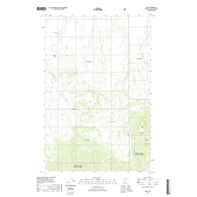
2020 Map of Evans
USGS Topo · Published 2020About this map
Evans sits within a complex drainage network in Cascade County, where the southern reaches of the map climb into the Lewis & Clark National Forest. The landscape is defined by its deep coulees and gulches, including Bayes Coulee and Dicks Gulch, which channel seasonal water toward the larger Sand Coulee Cr. A network of rural routes, such as Evans Riceville Rd and Beckstrom Rd, connects the scattered homesteads and ranches of this high-plains terrain. The prominence of Tiger Butte provides a significant local landmark in the eastern portion of the sheet, overlooking the headwaters of Tiger Cr. This 2020 survey illustrates the modern configuration of boundaries between private ranch lands and the protected forest area, showing how local hydrology like Half Breed Cr and the Middle Fork Sand Coulee Cr continues to dictate the placement of roads and settlements.
Find a feature on this map
25 named features on this map. Tap any name to fly to it.
Don’t see what you’re looking for? This feature index may not catch every label — zoom into the map to look around manually.
Map Details
Editions of this 2020 Evans Map
This is the sole edition of this map. No revisions or reprints were ever made.
Other maps of this area

1886 · Great Falls
USGS Topo · 1:250,000

1890 · Fort Benton
USGS Topo · 1:250,000

1892 · Fort Benton
USGS Topo · 1:250,000

1897 · Fort Benton
USGS Topo · 1:250,000

1954 · Great Falls
USGS Topo · 1:250,000

1955 · Stockett
USGS Topo · 1:62,500

1956 · Belt
USGS Topo · 1:62,500

1957 · Great Falls
USGS Topo · 1:250,000
1965 · Stockett
USGS Topo · 1:24,000

1965 · Mahoney Hill
USGS Topo · 1:24,000