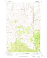
1971 Map of Evans
USGS Topo · Published 1975About this map
Evans is the primary settlement shown on this 1970s survey, situated along the northern boundary of the Lewis and Clark National Forest. The landscape is dominated by a complex network of seasonal drainages and coulees, reflecting a transition from the lower plains into the foothills of central Montana. Notable hydrological features include the Middle Fork Sand Coulee, Half Breed Creek, and the winding Sand Coulee Creek, which carve deep incisions into the local topography.
Find a feature on this map
19 named features on this map. Tap any name to fly to it.
Don’t see what you’re looking for? This feature index may not catch every label — zoom into the map to look around manually.
Map Details
Editions of this 1971 Evans Map
This is the sole edition of this map. No revisions or reprints were ever made.
Other maps of this area

1886 · Great Falls
USGS Topo · 1:250,000

1890 · Fort Benton
USGS Topo · 1:250,000

1892 · Fort Benton
USGS Topo · 1:250,000

1897 · Fort Benton
USGS Topo · 1:250,000

1954 · Great Falls
USGS Topo · 1:250,000

1955 · Stockett
USGS Topo · 1:62,500

1956 · Belt
USGS Topo · 1:62,500

1957 · Great Falls
USGS Topo · 1:250,000
1965 · Stockett
USGS Topo · 1:24,000

1965 · Mahoney Hill
USGS Topo · 1:24,000