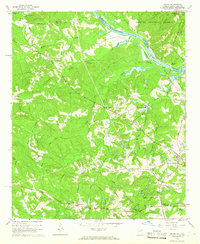
1964 Map of Evans
USGS Topo · Published 1966About this map
The Savannah River forms the primary geographic boundary of this 1960s survey, separating Georgia's Columbia County from McCormick County in South Carolina. The river landscape is defined by features like Little Germain Island and the Atlantic Coast Line Railroad which parallels the South Carolina bank through the Sumter National Forest. On the Georgia side, the terrain rises toward Burks Mountain, with a network of rural roads such as Old Petersburg Road and Middleton Ferry Road connecting early settlements.
Find a feature on this map
51 named features on this map. Tap any name to fly to it.
Don’t see what you’re looking for? This feature index may not catch every label — zoom into the map to look around manually.
Map Details
Editions of this 1964 Evans Map
3 editions found
Other maps of this area

1892 · Mc Cormick
USGS Topo · 1:125,000

1912 · Mc Cormick
USGS Topo · 1:125,000

1920 · Clarks Hill
USGS Topo · 1:48,000

1921 · Clarks Hill
USGS Topo · 1:62,500

1921 · Appling
USGS Topo · 1:62,500

1922 · Harlem
USGS Topo · 1:62,500

1922 · Hephzibah
USGS Topo · 1:62,500

1941 · Clarks Hill
USGS Topo · 1:62,500

1942 · Clarks Hill
USGS Topo · 1:62,500

1943 · Appling
USGS Topo · 1:62,500