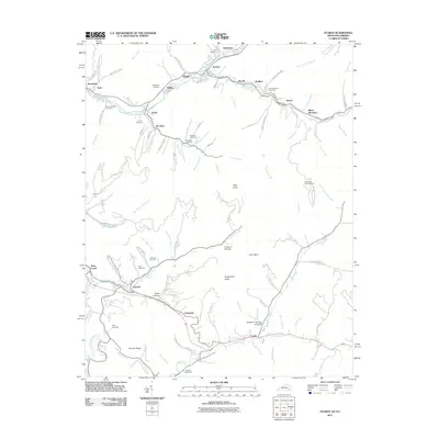
2011 Map of Evarts
USGS Topo · Published 2011About this map
The Clover Fork Cumberland River winds through a dense network of valley settlements, defining the social and industrial layout of this Appalachian corridor. During the early twenty-first century, the landscape remains anchored by towns like Evarts, Kenvir, and Verda, which follow the narrow lowlands between steep ridges. The abundance of family and community burial grounds, such as Middleton Cemetery, Rainbow Cemetery, and Pope Cemetery, provides significant data for genealogists tracing generations of local residents. Higher elevations are marked by landmarks like Little Black Lookout Tower and Sugarcamp Knob, while smaller hollows and branches like Cutshin Hollow and Bear Branch illustrate the intricate drainage patterns that historically dictated road placement and homesteading in Harlan County.
Find a feature on this map
98 named features on this map. Tap any name to fly to it.
Don’t see what you’re looking for? This feature index may not catch every label — zoom into the map to look around manually.
Map Details
Editions of this 2011 Evarts Map
This is the sole edition of this map. No revisions or reprints were ever made.
Other maps of this area

1887 · Jonesville
USGS Topo · 1:125,000

1891 · Jonesville
USGS Topo · 1:125,000

1903 · Harlan
USGS Topo · 1:48,000

1916 · Harlan
USGS Topo · 1:48,000

1916 · Nolansburg
USGS Topo · 1:48,000

1919 · Nolansburg
USGS Topo · 1:62,500

1919 · Harlan
USGS Topo · 1:62,500

1932 · Hagan
USGS Topo · 1:62,500

1935 · Hubbard Springs
USGS Topo · 1:24,000
1935 · Evarts
USGS Topo · 1:24,000