
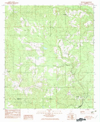
1982 Map of Evergreen
USGS Topo · Published 1982About this map
Evergreen stands as the central hub of this Conecuh County survey, positioned at the intersection of local commerce and the rolling landscape of south-central Alabama in the early 1980s. The map illustrates a town structured around its transportation corridors and the persistent flow of Murder Creek, which snakes past the western edge of the settlement. To the north, the smaller community of Owassa follows the path of the railroad, while outlying areas like Brownville and Centerville appear as established rural nodes connected by a developing network of improved and unimproved roads.
Find a feature on this map
9 named features on this map. Tap any name to fly to it.
Don’t see what you’re looking for? This feature index may not catch every label — zoom into the map to look around manually.
Map Details
Editions of this 1982 Evergreen Map
This is the sole edition of this map. No revisions or reprints were ever made.
Other maps of this area

1953 · Andalusia
USGS Topo · 1:250,000

1957 · Andalusia
USGS Topo · 1:250,000

1971 · Lyeffion
USGS Topo · 1:24,000

1971 · Castleberry
USGS Topo · 1:24,000

1971 · Belleville
USGS Topo · 1:24,000

1971 · Garland
USGS Topo · 1:24,000

1971 · China
USGS Topo · 1:24,000

1982 · Nymph
USGS Topo · 1:24,000

1982 · Old Town
USGS Topo · 1:24,000
1982 · Brooklyn
USGS Topo · 1:24,000