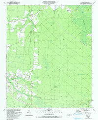
1990 Map of Exum
USGS Topo · Published 1990About this map
Green Swamp dominates this landscape, revealing a mosaic of wetlands and slightly elevated ridges that defined local settlement patterns in Brunswick County toward the end of the twentieth century. The small community of Exum sits along the northern edge, near the junction of Alligator Swamp and Swamp Bay. This area is characterized by numerous shallow depressions known as bays, including Alligator Bay, Wide Bay, and Good Luck Bay, which are interspersed with distinctive terrain features like Horse Pen Ridge and Big Neck. Local history is anchored by several rural landmarks, including St Matthew Ch, Trinity Ch, and the Griffin Cem near Mill Branch. The mapping of areas like Ludlum Pasture suggests a history of agricultural use carved out from the surrounding wetlands. This 1990 edition, which supersedes a 1943 Army Map Service survey, illustrates the persistence of these rural outposts and the complex hydrological network of Little Muddy Creek and Mill Swamp.
Find a feature on this map
42 named features on this map. Tap any name to fly to it.
Don’t see what you’re looking for? This feature index may not catch every label — zoom into the map to look around manually.
Map Details
Editions of this 1990 Exum Map
This is the sole edition of this map. No revisions or reprints were ever made.
Other maps of this area

1942 · Juniper Creek
USGS Topo · 1:24,000

1943 · Calabash
USGS Topo · 1:31,680

1943 · Freeland
USGS Topo · 1:24,000

1943 · Honey Island
USGS Topo · 1:24,000

1943 · Holden Beach
USGS Topo · 1:24,000

1943 · Exum
USGS Topo · 1:24,000

1943 · Supply
USGS Topo · 1:24,000

1943 · Shallotte
USGS Topo · 1:24,000

1944 · Supply
USGS Topo · 1:31,680

1944 · Shallotte
USGS Topo · 1:31,680