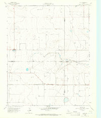
1965 Map of Exum
USGS Topo · Published 1966About this map
Exum stands as the primary rail point in this Texas Panhandle landscape, where the Chicago Rock Island and Pacific railroad cuts a straight line across the plains. The presence of Storage Bins at this junction underscores the area's agricultural reliance on rail transport for grain and livestock. The terrain is defined by the winding course of North Palo Duro Creek, which provides the only significant break in the flat topography. Beyond the small settlement of Exum, the map reveals an emerging energy economy, marked by numerous Gas Wells and an occasional Oil Well. This survey captures a moment where four Texas counties — Dallam, Hartley, Sherman, and Moore — converge at a single surveying point, illustrating the precise administrative boundaries of the High Plains during the mid-1960s.
Find a feature on this map
11 named features on this map. Tap any name to fly to it.
Don’t see what you’re looking for? This feature index may not catch every label — zoom into the map to look around manually.
Map Details
Editions of this 1965 Exum Map
This is the sole edition of this map. No revisions or reprints were ever made.
Other maps of this area

1954 · Tucumcari
USGS Topo · 1:250,000

1954 · Dalhart
USGS Topo · 1:250,000

1958 · Tucumcari
USGS Topo · 1:250,000

1958 · Dalhart
USGS Topo · 1:250,000

1962 · Dalhart
USGS Topo · 1:250,000

1963 · Hartley NE
USGS Topo · 1:24,000

1963 · Moran Ranch
USGS Topo · 1:24,000

1965 · Wilco
USGS Topo · 1:24,000

1965 · Lautz
USGS Topo · 1:24,000

1965 · Conlen
USGS Topo · 1:24,000