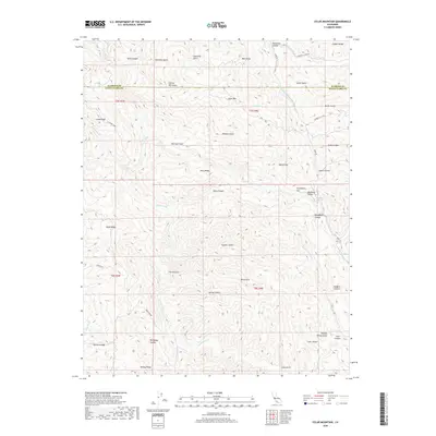
2018 Map of Eylar Mountain
USGS Topo · Published 2018About this map
Eylar Mtn rises as a central peak within the Diablo Range, overlooking a complex network of canyons and gulches that define the border between Alameda and Santa Clara counties. The landscape is carved by significant drainage systems including the Arroyo Valle and Arroyo Mocho, which dictate the orientation of the surrounding ridges. Historical access to this high-country terrain is marked by Mines Rd, a winding artery through the hills, and specialized cattle or resource corridors like Graveyard Rd. This 2018 survey reveals the persistent remote character of the region, where pockets of relatively level ground such as Sherman Flats, Ingram Flat, and Blackbird Valley stand out against the steep relief of Man Ridge and Valpe Ridge. The name-rich topography, from Horsethief Canyon to Deadman Gulch, hints at the storied ranching and mining heritage of the California Coast Ranges.
Find a feature on this map
55 named features on this map. Tap any name to fly to it.
Don’t see what you’re looking for? This feature index may not catch every label — zoom into the map to look around manually.
Map Details
Editions of this 2018 Eylar Mountain Map
This is the sole edition of this map. No revisions or reprints were ever made.
Other maps of this area

1897 · Mt. Hamilton
USGS Topo · 1:62,500

1907 · Tesla
USGS Topo · 1:62,500

1922 · Carbona
USGS Topo · 1:62,500

1938 · Mt. Boardman
USGS Topo · 1:62,500

1942 · Mt. Hamilton
USGS Topo · 1:62,500
1942 · Carbona
USGS Topo · 1:62,500

1942 · Mt. Boardman
USGS Topo · 1:62,500

1942 · Altamont
USGS Topo · 1:62,500
1943 · Tesla
USGS Topo · 1:62,500
1943 · Mt. Boardman
USGS Topo · 1:62,500